Gpolygon"
From Documentation
Robertwenzel (talk | contribs) m (→Example) |
|||
| (4 intermediate revisions by the same user not shown) | |||
| Line 4: | Line 4: | ||
*Demonstration: [http://www.zkoss.org/zkdemo/reporting/google_map Gmaps] | *Demonstration: [http://www.zkoss.org/zkdemo/reporting/google_map Gmaps] | ||
| − | *Java API: | + | *Java API: [https://github.com/zkoss/zkgmapsz/releases in release zip] |
*JavaScript API: N/A | *JavaScript API: N/A | ||
*Style Guide: N/A | *Style Guide: N/A | ||
| Line 17: | Line 17: | ||
<source lang="xml" > | <source lang="xml" > | ||
| − | |||
<script type="text/javascript" content="zk.googleAPIkey='Your-Google-API-Key'"/> | <script type="text/javascript" content="zk.googleAPIkey='Your-Google-API-Key'"/> | ||
<gmaps id="mymap" width="500px" height="300px" showSmallCtrl="true"> | <gmaps id="mymap" width="500px" height="300px" showSmallCtrl="true"> | ||
| − | <gpolygon | + | <gpolygon path="37.42838786,-122.13998795, |
| − | + | 37.43561240,-122.13277816, | |
| + | 37.42416187,-122.11441040, | ||
| + | 37.42157162,-122.12007522, | ||
| + | 37.41734524,-122.12316513, | ||
| + | 37.42838786,-122.13998795"/> | ||
</gmaps> | </gmaps> | ||
| − | |||
</source> | </source> | ||
== Disable Path Encoding == | == Disable Path Encoding == | ||
| − | + | {{versionSince| 3.3.0}} | |
see: [[ZK_Component_Reference/Diagrams_and_Reports/Gmaps/Gpolyline#Disable_Path_Encoding | Gpolyline - Disable_Path_Encoding]] | see: [[ZK_Component_Reference/Diagrams_and_Reports/Gmaps/Gpolyline#Disable_Path_Encoding | Gpolyline - Disable_Path_Encoding]] | ||
| Line 35: | Line 37: | ||
| − | {| | + | {| class='wikitable' | width="100%" |
! <center>Name</center> | ! <center>Name</center> | ||
! <center>Event Type</center> | ! <center>Event Type</center> | ||
| Line 50: | Line 52: | ||
=Use Cases= | =Use Cases= | ||
| − | {| | + | {| class='wikitable' | width="100%" |
! Version !! Description !! Example Location | ! Version !! Description !! Example Location | ||
|- | |- | ||
| Line 61: | Line 63: | ||
{{LastUpdated}} | {{LastUpdated}} | ||
| − | {| | + | {| class='wikitable' | width="100%" |
! Version !! Date !! Content | ! Version !! Date !! Content | ||
|- | |- | ||
Latest revision as of 09:32, 15 September 2023
Gpolygon
- Demonstration: Gmaps
- Java API: in release zip
- JavaScript API: N/A
- Style Guide: N/A
Employment/Purpose
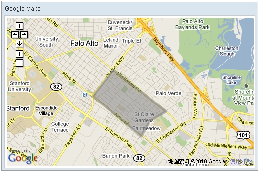
Polygon drawn on the Google Maps per the given (latitude, longitude) points, visible zoom level(0~3), and fill color, etc..
Example
    <script type="text/javascript" content="zk.googleAPIkey='Your-Google-API-Key'"/>
    <gmaps id="mymap" width="500px" height="300px" showSmallCtrl="true">
        <gpolygon path="37.42838786,-122.13998795,
                         37.43561240,-122.13277816,
                         37.42416187,-122.11441040,
                         37.42157162,-122.12007522,
                         37.41734524,-122.12316513,
                         37.42838786,-122.13998795"/>
    </gmaps>
Disable Path Encoding
Since 3.3.0
see: Gpolyline - Disable_Path_Encoding
Supported Events
| None | None |
- Inherited Supported Events: Gpolyline
Supported Children
*None
Use Cases
| Version | Description | Example Location |
|---|---|---|
Version History
| Version | Date | Content |
|---|---|---|
