Gimage"
From Documentation
m ((via JWB)) |
m (correct highlight (via JWB)) |
||
| Line 17: | Line 17: | ||
| − | <source lang="xml" | + | <source lang="xml" highlight='3'> |
<script type="text/javascript" content="zk.googleAPIkey='Your-Google-API-Key'"/> | <script type="text/javascript" content="zk.googleAPIkey='Your-Google-API-Key'"/> | ||
<gmaps id="mymap" width="500px" height="300px" showSmallCtrl="true"> | <gmaps id="mymap" width="500px" height="300px" showSmallCtrl="true"> | ||
Latest revision as of 08:04, 18 January 2022
Gimage
- Demonstration: Gmaps
- Java API: N/A
- JavaScript API: N/A
- Style Guide: N/A
Employment/Purpose
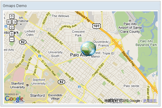
Image anchored on two specified (latitude, longitude) points(south-west and north-east) which is zoomed and moved with the Google Maps.
Example
    <script type="text/javascript" content="zk.googleAPIkey='Your-Google-API-Key'"/>
    <gmaps id="mymap" width="500px" height="300px" showSmallCtrl="true">
        <gimage src="/img/Centigrade-Widget-Icons/Globe-128x128.png"
swlat="37.44215478" swlng="-122.14273453" nelat="37.45033195" nelng="-122.13191986"/>
    </gmaps>
Supported Events
| None | None |
- Inherited Supported Events: XulElement
Supported Children
*None
Use Cases
| Version | Description | Example Location |
|---|---|---|
Version History
| Version | Date | Content |
|---|---|---|
