Gpolyline"
From Documentation
| Line 17: | Line 17: | ||
<source lang="xml" > | <source lang="xml" > | ||
| − | |||
<script type="text/javascript" content="zk.googleAPIkey='Your-Google-API-Key'"/> | <script type="text/javascript" content="zk.googleAPIkey='Your-Google-API-Key'"/> | ||
<gmaps id="mymap" width="500px" height="300px" showSmallCtrl="true"> | <gmaps id="mymap" width="500px" height="300px" showSmallCtrl="true"> | ||
| − | <gpolyline | + | <gpolyline path="37.42838786,-122.13998795, |
| − | + | 37.43561240,-122.13277816, | |
| + | 37.42416187,-122.11441040, | ||
| + | 37.42157162,-122.12007522, | ||
| + | 37.41734524,-122.12316513, | ||
| + | 37.42838786,-122.13998795"/> | ||
</gmaps> | </gmaps> | ||
| − | |||
</source> | </source> | ||
Latest revision as of 09:30, 15 September 2023
Gpolyline
- Demonstration: Gmaps
- Java API: in release zip
- JavaScript API: N/A
- Style Guide: N/A
Employment/Purpose
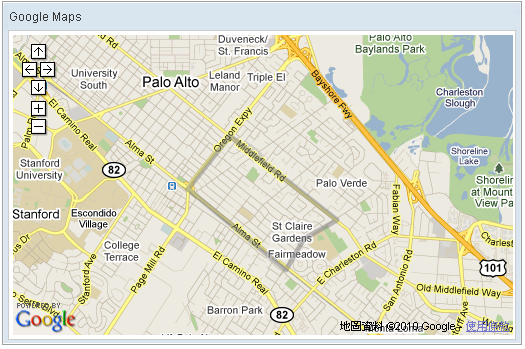
Polyline drawn on the Google Maps per the given (latitude, longitude) points and visible zoom level(0~3).
Example
    <script type="text/javascript" content="zk.googleAPIkey='Your-Google-API-Key'"/>
    <gmaps id="mymap" width="500px" height="300px" showSmallCtrl="true">
        <gpolyline path="37.42838786,-122.13998795,
                         37.43561240,-122.13277816,
                         37.42416187,-122.11441040,
                         37.42157162,-122.12007522,
                         37.41734524,-122.12316513,
                         37.42838786,-122.13998795"/>
    </gmaps>
Disable Path Encoding
Since 3.3.0
In order to preserve bandwidth the polyline/polygon path coordinates are encoded (default) with a lossy algorithm (i.e. some precision is lost - visible at high zoom levels). In cases where the highest precision is needed (e.g. when editing a polyline/polygon) this encoding can be disabled by setting pathEncoded="false" / polygon.setPathEncoded(false); - at the cost of increased network request and response sizes.
Supported Events
| None | None |
- Inherited Supported Events: XulElement
Supported Children
*None
Use Cases
| Version | Description | Example Location |
|---|---|---|
Version History
| Version | Date | Content |
|---|---|---|
